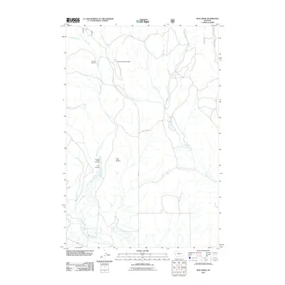
2011 Map of Mud Creek
USGS Topo · Published 2011About this map
Mud Creek and Daisy Dean Creek define the drainage patterns of this Wheatland County landscape, flowing through a series of canyons and coulees toward the North Fork Musselshell River at the southern edge of the sheet. The terrain is marked by distinctive topographic features such as Quaking Aspen Coulee, Picnic Canyon, and Long Canyon. Human intervention in the water system is evident through the presence of Mill Ditch and several curiously named stock or irrigation structures, including the Hundred Dollar Bill Dam and the Fifty Dollar Bill Dam. These dams, situated along the tributaries of Mud Creek, suggest a history of localized water management for ranching or agriculture in a semi-arid environment. Transportation in the area is limited to rural routes like Nevada Creek Rd and Findon Ln, reflecting the sparse, open-country character of the Montana plains in the early 21st century.
Find a feature on this map
15 named features on this map. Tap any name to fly to it.
Don’t see what you’re looking for? This feature index may not catch every label — zoom into the map to look around manually.
Map Details
Editions of this 2011 Mud Creek Map
This is the sole edition of this map. No revisions or reprints were ever made.
Other maps of this area

1886 · Little Belt Mts.
USGS Topo · 1:250,000

1894 · Little Belt Mts.
USGS Topo · 1:250,000

1897 · Little Belt Mts.
USGS Topo · 1:250,000

1898 · Little Belt Mts.
USGS Topo · 1:250,000

1902 · Little Belt Mts.
USGS Topo · 1:250,000

1948 · White Sulphur Springs
USGS Topo · 1:250,000

1958 · White Sulphur Springs
USGS Topo · 1:250,000

1961 · White Sulphur Springs
USGS Topo · 1:250,000

1965 · White Sulphur Springs
USGS Topo · 1:250,000
1972 · Daisy Peak
USGS Topo · 1:24,000