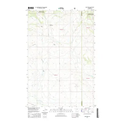
2017 Map of Mud Creek
USGS Topo · Published 2017About this map
Lewis & Clark National Forest defines the northern reaches of this landscape, where the terrain transitions from timbered slopes into the dramatic drainages of the high plains. The topography is dominated by a series of significant erosional features, including the deep Long Canyon, Picnic Canyon, and the broad expanse of Big Coulee. Water management and natural drainage patterns are central to the area's geography, with the N Fork Musselshell River flowing along the southern boundary and the man-made Mill Ditch cutting across the southwestern quadrant. This 2017 survey illustrates the intersection of public forest lands and ranching infrastructure, connected by corridors like Findon Ln and Raschke Ranch Rd that navigate the coulees and creek beds including Mud Creek and Daisy Dean Cr.
Find a feature on this map
20 named features on this map. Tap any name to fly to it.
Don’t see what you’re looking for? This feature index may not catch every label — zoom into the map to look around manually.
Map Details
Editions of this 2017 Mud Creek Map
This is the sole edition of this map. No revisions or reprints were ever made.
Other maps of this area

1886 · Little Belt Mts.
USGS Topo · 1:250,000

1894 · Little Belt Mts.
USGS Topo · 1:250,000

1897 · Little Belt Mts.
USGS Topo · 1:250,000

1898 · Little Belt Mts.
USGS Topo · 1:250,000

1902 · Little Belt Mts.
USGS Topo · 1:250,000

1948 · White Sulphur Springs
USGS Topo · 1:250,000

1958 · White Sulphur Springs
USGS Topo · 1:250,000

1961 · White Sulphur Springs
USGS Topo · 1:250,000

1965 · White Sulphur Springs
USGS Topo · 1:250,000
1972 · Daisy Peak
USGS Topo · 1:24,000