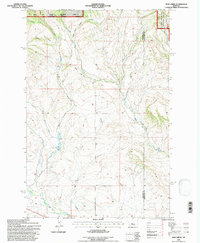
1995 Map of Mud Creek
USGS Topo · Published 1997About this map
The Lewis and Clark National Forest Musselshell Ranger District dominates the northern reaches of this mid-1990s survey, where the rugged topography of Meagher County meets the Wheatland County line. The drainage network is particularly intricate here, defined by the North Fork Musselshell River and its varied tributaries, including the aptly named Alkali Mud Creek and the meandering Mud Creek. A distinct transition from the forested highlands to the open drainages is visible through features like Quaking Aspen Coulee and Big Coulee. Human activity in this remote Montana landscape is marked by the presence of a Gravel Pit and the long transit of Findon Lane, which cuts through the southern drainage basins. This map provides a clear record of land management boundaries and the natural watercourse names that defined ranching and forest service operations in the late 20th century.
Find a feature on this map
17 named features on this map. Tap any name to fly to it.
Don’t see what you’re looking for? This feature index may not catch every label — zoom into the map to look around manually.
Map Details
Editions of this 1995 Mud Creek Map
This is the sole edition of this map. No revisions or reprints were ever made.
Other maps of this area

1886 · Little Belt Mts.
USGS Topo · 1:250,000

1894 · Little Belt Mts.
USGS Topo · 1:250,000

1897 · Little Belt Mts.
USGS Topo · 1:250,000

1898 · Little Belt Mts.
USGS Topo · 1:250,000

1902 · Little Belt Mts.
USGS Topo · 1:250,000

1948 · White Sulphur Springs
USGS Topo · 1:250,000

1958 · White Sulphur Springs
USGS Topo · 1:250,000

1961 · White Sulphur Springs
USGS Topo · 1:250,000

1965 · White Sulphur Springs
USGS Topo · 1:250,000
1972 · Daisy Peak
USGS Topo · 1:24,000