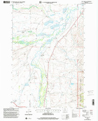
1997 Map of Mud Creek
USGS Topo · Published 2002About this map
The Big Hole River and its complex network of tributaries, including the North Fork Big Hole River and Plimpton Creek, dominate this high-altitude landscape. The terrain shows a distinct pattern of valley floor ranching and upland conservation within the Beaverhead National Forest. This era of the late 1990s is marked by deep-rooted family land holdings, notably the Mussigbrod Homestead, Mc Vey Homestead, and Rutledge Ranch, illustrating the persistent agricultural heritage of the region. Near the center of the valley sits the Wisdom Cem, a critical site for local genealogical research. Historically, the land is traversed by the Lewis and Clark Natl Historic Trail, which follows the southern reaches of Swamp Creek, connecting the modern landscape to its 19th-century exploration roots.
Find a feature on this map
19 named features on this map. Tap any name to fly to it.
Don’t see what you’re looking for? This feature index may not catch every label — zoom into the map to look around manually.
Map Details
Editions of this 1997 Mud Creek Map
This is the sole edition of this map. No revisions or reprints were ever made.
Other maps of this area

1886 · Little Belt Mts.
USGS Topo · 1:250,000

1894 · Little Belt Mts.
USGS Topo · 1:250,000

1897 · Little Belt Mts.
USGS Topo · 1:250,000

1898 · Little Belt Mts.
USGS Topo · 1:250,000

1902 · Little Belt Mts.
USGS Topo · 1:250,000

1948 · White Sulphur Springs
USGS Topo · 1:250,000

1958 · White Sulphur Springs
USGS Topo · 1:250,000

1961 · White Sulphur Springs
USGS Topo · 1:250,000

1965 · White Sulphur Springs
USGS Topo · 1:250,000
1972 · Daisy Peak
USGS Topo · 1:24,000