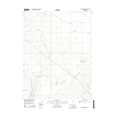
2014 Map of Mud Lake Reservoir
USGS Topo · Published 2014About this map
Snake Valley defines the arid character of this Juab County landscape, where water management is central to the local geography. The Mud Lake Reservoir serves as a primary landmark, reached by Mud Lake Reservoir Rd south of the Weiss Hwy. The map details a network of drainage systems including Indian Farm Cr, Toms Cr, and Red Cedar Cr, which highlight the essential role of seasonal water in this high-desert environment. Ranching and transit history are visible in the naming of roads such as Granite Ranch Field Rd and the E Pony Exp at the northern edge. This area, marked by expansive flats and ranch-related infrastructure, reflects the specialized land use required to sustain life and agriculture in western Utah's basins.
Find a feature on this map
23 named features on this map. Tap any name to fly to it.
Don’t see what you’re looking for? This feature index may not catch every label — zoom into the map to look around manually.
Map Details
Editions of this 2014 Mud Lake Reservoir Map
This is the sole edition of this map. No revisions or reprints were ever made.
Other maps of this area

1908 · Fish Springs
USGS Topo · 1:250,000

1910 · Fish Springs
USGS Topo · 1:250,000

1953 · Delta
USGS Topo · 1:250,000

1958 · Delta
USGS Topo · 1:250,000

1960 · Granite Mountain
USGS Topo · 1:62,500

1961 · Trout Creek
USGS Topo · 1:62,500

1962 · Delta
USGS Topo · 1:250,000

1972 · Mud Lake Reservoir
USGS Topo · 1:24,000
1972 · Boyd Station
USGS Topo · 1:24,000
1972 · Goshute Canyon
USGS Topo · 1:24,000