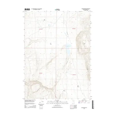
2015 Map of Mud Meadow
USGS Topo · Published 2015About this map
Soldier Meadows Hot Springs sits at the heart of this high-desert landscape in northwestern Nevada, where geothermal activity meets the arid expanse of the Great Basin. This 2015 survey documents a region defined by its water sources and dramatic elevation changes, notably where the Mud Meadow Cr feeds into the Mud Meadow Reservoir. The map illustrates how human movement is dictated by the terrain, with Soldier Meadows Rd tracking through the valley floor between the towering Black Mtn and the northern tip of the Black Rock Desert. In addition to the primary springs, smaller water features like Mud Spring and Wheeler Spring appear as vital points in an environment carved by deep geographic cuts, including Fly Canyon and Box Canyon. This study reflects the remote character of Humboldt County, highlighting the sparse but essential infrastructure required to navigate this portion of the sagebrush steppe.
Find a feature on this map
17 named features on this map. Tap any name to fly to it.
Don’t see what you’re looking for? This feature index may not catch every label — zoom into the map to look around manually.
Map Details
Editions of this 2015 Mud Meadow Map
This is the sole edition of this map. No revisions or reprints were ever made.
Other maps of this area

1889 · Long Valley
USGS Topo · 1:250,000

1954 · Vya
USGS Topo · 1:250,000

1958 · Vya
USGS Topo · 1:250,000

1962 · Vya
USGS Topo · 1:250,000

1972 · Mud Meadow
USGS Topo · 1:24,000

1972 · Soldier Meadow
USGS Topo · 1:24,000

1972 · High Rock Lake
USGS Topo · 1:24,000

1972 · Big Mountain
USGS Topo · 1:24,000
1972 · Red Mountain
USGS Topo · 1:24,000
1972 · Yellow Hills East
USGS Topo · 1:24,000