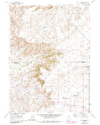
1960 Map of Mud Springs
USGS Topo · Published 1985About this map
Bates Hole defines this central Wyoming landscape, where the high desert terrain transitions across the Natrona and Carbon County line. Surveyed in 1960 with updates through the early 1980s, the map reveals a remote ranching and transit corridor shaped by water scarcity and steep relief. Ranching infrastructure is evident through the named Chalk Hill Reservoirs, Lost Reservoir, and the distinctive Cronberg Pit Reservoirs, which likely supported livestock grazing in this arid environment. The transport network is anchored by the Casper Medicine Bow Highway and a series of secondary routes like the Stock Trail, tracing the natural paths provided by Shirley Ridge and Moss Agate Ridge. Mud Springs and Antelope Springs appear as vital natural landmarks for early travelers and locals navigating the drainage basins of Lone Tree Creek and Bates Hole Creek.
Find a feature on this map
19 named features on this map. Tap any name to fly to it.
Don’t see what you’re looking for? This feature index may not catch every label — zoom into the map to look around manually.
Map Details
Editions of this 1960 Mud Springs Map
2 editions found
Other maps of this area

1955 · Casper
USGS Topo · 1:250,000

1958 · Casper
USGS Topo · 1:250,000

1959 · Moss Agate Reservoir
USGS Topo · 1:24,000

1959 · Bates Creek Reservoir
USGS Topo · 1:24,000

1960 · Twin Buttes
USGS Topo · 1:24,000

1960 · Wild Irish Reservoir
USGS Topo · 1:24,000

1960 · Horse Peak
USGS Topo · 1:24,000

1960 · Sheep Creek
USGS Topo · 1:24,000

1960 · Mud Springs
USGS Topo · 1:24,000

1960 · Measel Spring Reservoir
USGS Topo · 1:24,000