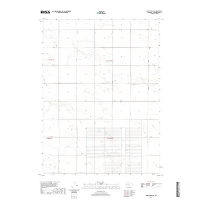
2017 Map of Mud Springs SE
USGS Topo · Published 2017About this map
Salem Cem stands as a primary landmark in this rural landscape within t16n r50w, reflecting the area's pioneer heritage in southern Nebraska. The terrain is defined by the ephemeral path of Rush Cr, which wanders through the townships of t16n r51w and t15n r50w. The map depicts an orderly grid of county roads, including RD 101 and RD 44, that delineate the section lines across this agricultural expanse. A unique grid system of unpaved paths or property divisions is visible in the southern portion of the quadrangle, suggesting specific historical land use patterns or planned developments near the Cheyenne County border.
Find a feature on this map
21 named features on this map. Tap any name to fly to it.
Don’t see what you’re looking for? This feature index may not catch every label — zoom into the map to look around manually.
Map Details
Editions of this 2017 Mud Springs SE Map
This is the sole edition of this map. No revisions or reprints were ever made.
Other maps of this area

1899 · Sidney
USGS Topo · 1:125,000

1954 · Scottsbluff
USGS Topo · 1:250,000

1958 · Scottsbluff
USGS Topo · 1:250,000

1972 · Gurley
USGS Topo · 1:24,000

1972 · Mud Springs SW
USGS Topo · 1:24,000
1972 · Dalton
USGS Topo · 1:24,000

1972 · Point Of Rocks
USGS Topo · 1:24,000

1972 · Brownson
USGS Topo · 1:24,000

1972 · Horsehead Ranch
USGS Topo · 1:24,000

1972 · Mud Springs SE
USGS Topo · 1:24,000