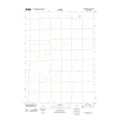
2011 Map of Mud Springs SW
USGS Topo · Published 2011About this map
Rush Creek and the drainage of Wild Horse Draw define this portion of the Nebraska panhandle, where a rigid grid of rural section roads organizes the high plains landscape. This survey of southern Cheyenne County illustrates the expansive agricultural layout of the region in the early 21st century. The map is dominated by an intersection of county routes including Road 50, Road 48, and Road 40 running east-to-west, crossed by north-to-south arteries like Road 89 and Road 91. The topography is relatively level, marked primarily by the subtle meandering paths of intermittent watercourses that break the geometric regularity of the farming parcels. This document serves as a precise record of modern land divisions and property access points in a sparsely populated agricultural corridor.
Find a feature on this map
17 named features on this map. Tap any name to fly to it.
Don’t see what you’re looking for? This feature index may not catch every label — zoom into the map to look around manually.
Map Details
Editions of this 2011 Mud Springs SW Map
This is the sole edition of this map. No revisions or reprints were ever made.
Other maps of this area

1954 · Scottsbluff
USGS Topo · 1:250,000

1958 · Scottsbluff
USGS Topo · 1:250,000

1972 · Mud Springs SW
USGS Topo · 1:24,000

1972 · Point Of Rocks
USGS Topo · 1:24,000

1972 · Brownson
USGS Topo · 1:24,000

1972 · Horsehead Ranch
USGS Topo · 1:24,000

1972 · Mud Springs SE
USGS Topo · 1:24,000
1972 · Mud Springs
USGS Topo · 1:24,000

1972 · Potter
USGS Topo · 1:24,000

1973 · Potter 2 SE
USGS Topo · 1:24,000