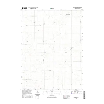
2014 Map of Mud Springs SW
USGS Topo · Published 2014About this map
Wild Horse Draw and the drainage of Rush Cr define the high plains landscape of Cheyenne County in this modern survey. The map reveals a strictly regulated agrarian grid, where section lines are almost exclusively occupied by local routes such as Road 52, Road 50, and Road 36. This systematic road network illustrates the enduring influence of the Public Land Survey System on the Nebraska panhandle, dividing the open range into precise rectangular blocks for contemporary ranching and farming operations. The scarcity of named landmarks or settlements highlights the immense scale of individual land holdings in this portion of the state, where water features like Rush Cr remain the primary natural orientation points for residents navigating between the long stretches of north-south connectors like Road 91 and Road 97.
Find a feature on this map
18 named features on this map. Tap any name to fly to it.
Don’t see what you’re looking for? This feature index may not catch every label — zoom into the map to look around manually.
Map Details
Editions of this 2014 Mud Springs SW Map
This is the sole edition of this map. No revisions or reprints were ever made.
Other maps of this area

1954 · Scottsbluff
USGS Topo · 1:250,000

1958 · Scottsbluff
USGS Topo · 1:250,000

1972 · Mud Springs SW
USGS Topo · 1:24,000

1972 · Point Of Rocks
USGS Topo · 1:24,000

1972 · Brownson
USGS Topo · 1:24,000

1972 · Horsehead Ranch
USGS Topo · 1:24,000

1972 · Mud Springs SE
USGS Topo · 1:24,000
1972 · Mud Springs
USGS Topo · 1:24,000

1972 · Potter
USGS Topo · 1:24,000

1973 · Potter 2 SE
USGS Topo · 1:24,000