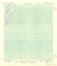
1954 Map of Mudpan Bayou
USGS Topo · Published 1954About this map
Southwest Pass defines the slender landform of the Mississippi River Delta on this 1954 advance sheet, where the river meets the Gulf of Mexico. This survey, based on aerial photographs taken by the Air Corps, U. S. Army, and field examinations by the U.S. Geological Survey in 1935, documents the shifting coastal geography of Plaquemines Parish before significant mid-century changes. The landscape is dominated by marshland and tidal channels, most notably Mudpan Bayou and Burrwood Bayou, which snake through the narrow strip of land separating the pass from West Bay. The inclusion of land lines from the General Land Office records offers a glimpse into the legal and navigational partitioning of this maritime environment, providing essential data for those studying the evolution of the Louisiana coastline and its vital waterways.
Find a feature on this map
5 named features on this map. Tap any name to fly to it.
Don’t see what you’re looking for? This feature index may not catch every label — zoom into the map to look around manually.
Map Details
Editions of this 1954 Mudpan Bayou Map
This is the sole edition of this map. No revisions or reprints were ever made.
Other maps of this area

1893 · East Delta
USGS Topo · 1:62,500

1893 · West Delta
USGS Topo · 1:62,500

1935 · South Pass
USGS Topo · 1:31,680

1946 · Pass Du Bois
USGS Topo · 1:31,680

1946 · Mudpan Bayou
USGS Topo · 1:31,680

1947 · Southwest Pass
USGS Topo · 1:31,680
1949 · Burrwood
USGS Topo · 1:31,680

1952 · Southwest Pass
USGS Topo · 1:62,500

1953 · West Delta
USGS Topo · 1:62,500
1954 · Pass Du Bois
USGS Topo · 1:31,680