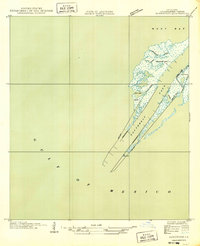
1949 Map of Burrwood
USGS Topo · Published 1949About this map
Southwest Pass forms the narrow, engineered corridor at the very tip of the Mississippi River delta, serving as a critical maritime gateway to the Gulf of Mexico. The isolated settlement of Burrwood stands as a lonely outpost amidst the marshy terrain, connected to the river channel by the Sanitary Canal and Burrwood Bayou. Navigational infrastructure dominates this 1935 field examination, with the Southwest Pass L. H. and the Pilot Sta providing essential guidance for vessels navigating the shifting silt and currents. Long stretches of the West Jetty and East Jetty, reinforced by a Protection Wall, define the channel, while surrounding features like Lighthouse Bayou and Mud Bay illustrate the fragile, water-bound geography of Plaquemines Parish before modern coastal changes.
Find a feature on this map
18 named features on this map. Tap any name to fly to it.
Don’t see what you’re looking for? This feature index may not catch every label — zoom into the map to look around manually.
Map Details
Editions of this 1949 Burrwood Map
This is the sole edition of this map. No revisions or reprints were ever made.
Other maps of this area

1893 · West Delta
USGS Topo · 1:62,500

1946 · Pass Du Bois
USGS Topo · 1:31,680

1946 · Mudpan Bayou
USGS Topo · 1:31,680

1947 · Southwest Pass
USGS Topo · 1:31,680

1952 · Southwest Pass
USGS Topo · 1:62,500

1953 · West Delta
USGS Topo · 1:62,500
1954 · Pass Du Bois
USGS Topo · 1:31,680
1954 · Southwest Pass
USGS Topo · 1:31,680
1954 · Mudpan Bayou
USGS Topo · 1:31,680

1957 · Breton Sound
USGS Topo · 1:250,000