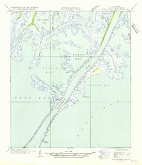
1954 Map of Southwest Pass
USGS Topo · Published 1954About this map
The Southwest Pass serves as the dominant navigational corridor through the Mississippi River delta, as captured in this mid-century survey. The landscape is a complex of wetlands and secondary waterways, including Tom Loar Pass and William Pass, which cut through the marsh toward larger bodies of water like Zinzin Bay and Dixon Bay. Inland features such as Bob Taylors Pond and family-named bayous like Sullivan Bayou suggest a long history of local use for fishing and navigation before more intensive modern engineering.
Find a feature on this map
20 named features on this map. Tap any name to fly to it.
Don’t see what you’re looking for? This feature index may not catch every label — zoom into the map to look around manually.
Map Details
Editions of this 1954 Southwest Pass Map
This is the sole edition of this map. No revisions or reprints were ever made.
Other maps of this area

1893 · East Delta
USGS Topo · 1:62,500

1893 · West Delta
USGS Topo · 1:62,500

1935 · South Pass
USGS Topo · 1:31,680

1946 · Pass Du Bois
USGS Topo · 1:31,680

1946 · Mudpan Bayou
USGS Topo · 1:31,680

1946 · Pass Tante Phine
USGS Topo · 1:31,680

1947 · Pass A Loutre West
USGS Topo · 1:31,680

1947 · Southwest Pass
USGS Topo · 1:31,680

1949 · Cubits Gap
USGS Topo · 1:31,680
1949 · Burrwood
USGS Topo · 1:31,680