
1957 Map of Breton Sound
USGS Topo · Published 1967About this map
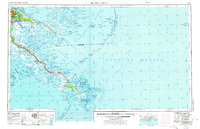
The Mississippi River creates the defining geometry of this 1957 coastal survey, carving through the marshlands as it approaches the Gulf of Mexico. Along its banks, a string of historic river settlements such as Pointe a la Hache, Bohemia, and Port Sulphur reflect the region's deep connection to the water and the river-borne economy. To the east, the sprawling waters of Breton Sound and Chandeleur Sound are shielded from the open sea by the arc of the Chandeleur Islands.
Find a feature on this map
84 named features on this map. Tap any name to fly to it.
Don’t see what you’re looking for? This feature index may not catch every label — zoom into the map to look around manually.
Map Details
Editions of this 1957 Breton Sound Map
3 editions found

Other maps of this area

1891 · Spanish Fort
USGS Topo · 1:62,500

1891 · Pointe a La Hache
USGS Topo · 1:62,500

1891 · New Orleans
USGS Topo · 1:62,500

1892 · Barataria
USGS Topo · 1:62,500
1892 · Cheniere Caminada
USGS Topo · 1:62,500

1892 · Chef Menteur
USGS Topo · 1:62,500

1892 · Quarantine
USGS Topo · 1:62,500

1892 · Creole
USGS Topo · 1:62,500

1892 · St. Bernard
USGS Topo · 1:62,500

1892 · Pointe a La Hache
USGS Topo · 1:62,500