
1957 Map of Breton Sound
USGS Topo · Published 1983About this map
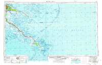
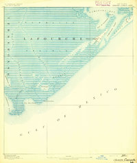
The Mississippi River Delta and the arc of the Chandeleur Islands dominate this 1957 survey, which highlights the precarious balance of the Louisiana coastline before significant late-century erosion. Small riverfront communities such as Poydras, Braithwaite, and Phoenix line the Mississippi River as it winds toward the gulf, while the Southern Pacific railroad tracks provide a vital link for the industry at Port Sulphur. The map documents the sprawling network of bayous and lakes, including Lake Lery and Lake Coquille, that define the landscape of St Bernard Parish and Plaquemines Parish. Protective designations like the Breton National Wildlife Refuge and Delta National Wildlife Refuge are clearly marked, as are the historic defensive positions at Fort Jackson and Fort St Philip, which have guarded the river's approach for generations.
Find a feature on this map
165 named features on this map. Tap any name to fly to it.
Don’t see what you’re looking for? This feature index may not catch every label — zoom into the map to look around manually.
Map Details
Editions of this 1957 Breton Sound Map
3 editions found

Other maps of this area

1891 · Spanish Fort
USGS Topo · 1:62,500

1891 · Pointe a La Hache
USGS Topo · 1:62,500

1891 · New Orleans
USGS Topo · 1:62,500

1892 · Barataria
USGS Topo · 1:62,500
1892 · Cheniere Caminada
USGS Topo · 1:62,500

1892 · Chef Menteur
USGS Topo · 1:62,500

1892 · Quarantine
USGS Topo · 1:62,500

1892 · Creole
USGS Topo · 1:62,500

1892 · St. Bernard
USGS Topo · 1:62,500

1892 · Pointe a La Hache
USGS Topo · 1:62,500