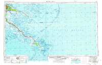
1957 Map of Breton Sound
USGS Topo · Published 1974About this map
The Mississippi River Delta fans out into the Gulf of Mexico, revealing a complex network of bayous, passes, and marshes in the mid-20th century. This survey documents the critical transition from the urban density of New Orleans to the remote coastal fringes of the Chalmette National Historical Park and beyond. The map provides an essential record of early industrial and transit development, featuring the Southern Railway System and the emerging Gulf Outlet Canal. Along the river's lower reaches, historical military outposts like Fort Jackson and Fort St Philip stand as sentinels near the bird-foot delta. Further east, the sweeping arc of the Chandeleur Islands and the Breton Islands illustrates the fragile barrier island system before decades of coastal erosion. Inhabitants of Plaquemines Parish and St Bernard Parish are represented by river-bound settlements such as Pointe a la Hache, Phoenix, and Buras.
Find a feature on this map
100 named features on this map. Tap any name to fly to it.
Don’t see what you’re looking for? This feature index may not catch every label — zoom into the map to look around manually.
Map Details
Editions of this 1957 Breton Sound Map
3 editions found

Other maps of this area

1891 · Spanish Fort
USGS Topo · 1:62,500

1891 · Pointe a La Hache
USGS Topo · 1:62,500

1891 · New Orleans
USGS Topo · 1:62,500

1892 · Barataria
USGS Topo · 1:62,500

1892 · Cheniere Caminada
USGS Topo · 1:62,500

1892 · Chef Menteur
USGS Topo · 1:62,500

1892 · Quarantine
USGS Topo · 1:62,500

1892 · Creole
USGS Topo · 1:62,500

1892 · St. Bernard
USGS Topo · 1:62,500

1892 · Pointe a La Hache
USGS Topo · 1:62,500