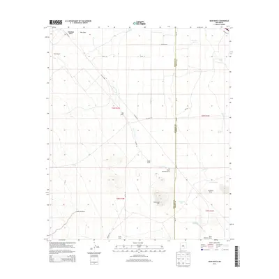
2013 Map of Muir Ranch
USGS Topo · Published 2013About this map
Mitchell Place sits near the northern boundary of this high-desert landscape in the southwestern corner of New Mexico. The terrain is defined by a complex network of ephemeral watercourses and drainage basins, most notably the winding Burro Cienaga which cuts through the center of the sheet alongside Pride Draw and Muir Draw. The presence of numerous water-management features, such as Homestead Tank and Brockman Dirt Tank, underscores the importance of ranching in this arid environment.
Find a feature on this map
33 named features on this map. Tap any name to fly to it.
Don’t see what you’re looking for? This feature index may not catch every label — zoom into the map to look around manually.
Map Details
Editions of this 2013 Muir Ranch Map
This is the sole edition of this map. No revisions or reprints were ever made.
Other maps of this area

1954 · Silver City
USGS Topo · 1:250,000

1958 · Silver City
USGS Topo · 1:250,000

1962 · Silver City
USGS Topo · 1:250,000

1962 · Ninetysix Ranch
USGS Topo · 1:24,000

1962 · Lisbon
USGS Topo · 1:24,000

1963 · Lordsburg
USGS Topo · 1:24,000

1964 · Muir Ranch
USGS Topo · 1:24,000
1964 · South Pyramid Peak
USGS Topo · 1:24,000

1964 · Pyramid Peak
USGS Topo · 1:24,000
1964 · Separ
USGS Topo · 1:24,000