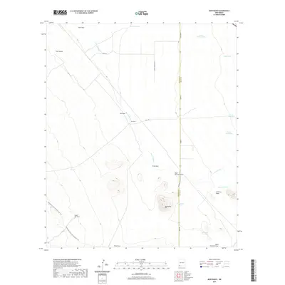
2020 Map of Muir Ranch
USGS Topo · Published 2020About this map
Muir Ranch sits at the heart of this high-desert landscape on the border of Hidalgo and Grant Counties. The drainage systems of Muir Draw, Uhl Draw, and Pride Draw define the local topography, feeding into the wider Lordsburg Valley. To the south, the Continental Divide National Scenic Trail winds through the terrain, passing landmarks such as South Uhl Draw and Homestead Hill. The map documents a ranching environment where water management is critical, illustrated by a network of tanks including Homestead Tank, North Dirt Tank, and Cooper Tank. Natural water features like the Burro Cienaga and the intermittent flow of Ninetysix Cr contrast with the geometric grid of range lines and local ranch roads like Muir Rd and Bar T Rd.
Find a feature on this map
31 named features on this map. Tap any name to fly to it.
Don’t see what you’re looking for? This feature index may not catch every label — zoom into the map to look around manually.
Map Details
Editions of this 2020 Muir Ranch Map
This is the sole edition of this map. No revisions or reprints were ever made.
Other maps of this area

1954 · Silver City
USGS Topo · 1:250,000

1958 · Silver City
USGS Topo · 1:250,000

1962 · Silver City
USGS Topo · 1:250,000

1962 · Ninetysix Ranch
USGS Topo · 1:24,000

1962 · Lisbon
USGS Topo · 1:24,000

1963 · Lordsburg
USGS Topo · 1:24,000

1964 · Muir Ranch
USGS Topo · 1:24,000
1964 · South Pyramid Peak
USGS Topo · 1:24,000

1964 · Pyramid Peak
USGS Topo · 1:24,000
1964 · Separ
USGS Topo · 1:24,000