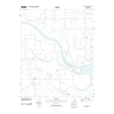
2010 Map of Muldrow SW
USGS Topo · Published 2010About this map
The Arkansas River dictates the landscape of this region, winding through a series of fertile lowlands and bottomlands that have long shaped local life. In the river's broad floodplains, named regions like Tucker Bottom and Cache Bottom illustrate the historical importance of these alluvial plains for agriculture. The settlement pattern is defined by small, clustered communities such as Foreman, Tucker, and Cowlington, which are connected by a grid-like network of county roads like Co RD 46. The topography is marked by numerous watercourses feeding into the main river, including the northern Big Skin Bayou and Onion Creek, alongside Cache Creek to the south. Center Point Cemetery serves as a significant genealogical landmark, while outlying points like Stony Point help define the rural boundaries of this Sequoyah County territory during the early 21st century.
Find a feature on this map
53 named features on this map. Tap any name to fly to it.
Don’t see what you’re looking for? This feature index may not catch every label — zoom into the map to look around manually.
Map Details
Editions of this 2010 Muldrow SW Map
This is the sole edition of this map. No revisions or reprints were ever made.
Other maps of this area

1900 · Sallisaw
USGS Topo · 1:125,000

1911 · Sallisaw
USGS Topo · 1:125,000

1946 · Fort Smith
USGS Topo · 1:250,000

1965 · Fort Smith
USGS Topo · 1:250,000
1966 · Muldrow
USGS Topo · 1:24,000

1966 · Gans
USGS Topo · 1:24,000

1966 · Muldrow SW
USGS Topo · 1:24,000

1967 · Fort Smith
USGS Topo · 1:250,000
1967 · Sallisaw
USGS Topo · 1:24,000

1967 · Robert S Kerr Dam
USGS Topo · 1:24,000