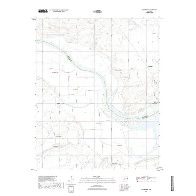
2018 Map of Muldrow SW
USGS Topo · Published 2018About this map
The Arkansas River carves a broad, winding path through this portion of eastern Oklahoma, defining the border between Sequoyah Co and Le Flore Co. The landscape is characterized by extensive lowlands and alluvial plains, most notably Tucker Bottom and Cache Bottom, which have long influenced the agricultural and settlement patterns of the region. Local communities are scattered throughout the river valley, with Foreman and Redland situated on the northern side, while Cowlington and Stony Point occupy the terrain to the south. Small watercourses like Cache Cr, Pecan Cr, and Big Skin Bayou feed into the main river channel, creating a complex drainage network. For those researching local heritage, the map identifies specific points of interest including Center Point Cem and Redland Cem, as well as the intricate network of rural roads that connect these riverside settlements.
Find a feature on this map
73 named features on this map. Tap any name to fly to it.
Don’t see what you’re looking for? This feature index may not catch every label — zoom into the map to look around manually.
Map Details
Editions of this 2018 Muldrow SW Map
This is the sole edition of this map. No revisions or reprints were ever made.
Other maps of this area

1900 · Sallisaw
USGS Topo · 1:125,000

1911 · Sallisaw
USGS Topo · 1:125,000

1946 · Fort Smith
USGS Topo · 1:250,000

1965 · Fort Smith
USGS Topo · 1:250,000
1966 · Muldrow
USGS Topo · 1:24,000

1966 · Gans
USGS Topo · 1:24,000

1966 · Muldrow SW
USGS Topo · 1:24,000

1967 · Fort Smith
USGS Topo · 1:250,000
1967 · Sallisaw
USGS Topo · 1:24,000

1967 · Robert S Kerr Dam
USGS Topo · 1:24,000