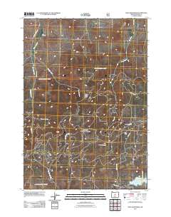
2011 Map of Mule Deer Ridge
USGS Topo · Published 2011About this map
Knox Cemetery sits in the northwest corner of this Crook County terrain, overlooking the drainage of Newsome Creek and Sherwood Creek. The landscape is dominated by the high elevations of the Maury Mountains and the namesake Mule Deer Ridge, where numerous seasonal and perennial streams like Hammer Creek and Klootchman Creek carve through the high desert forest. This area of central Oregon is defined by its recreation and resource management infrastructure, including the Pine Creek Campground near Pine Creek and the southern Antelope Flat Reservoir. Small plateaus or clearings such as Flag Flat and Lillie Flat provide landmarks along the network of forest roads, including Maury Rd and SE Newsom Creek Rd, which navigate the complex topography of the range.
Find a feature on this map
19 named features on this map. Tap any name to fly to it.
Don’t see what you’re looking for? This feature index may not catch every label — zoom into the map to look around manually.
Map Details
Editions of this 2011 Mule Deer Ridge Map
This is the sole edition of this map. No revisions or reprints were ever made.
Other maps of this area

1946 · Eagle Rock
USGS Topo · 1:62,500

1948 · Eagle Rock
USGS Topo · 1:62,500

1951 · Post
USGS Topo · 1:62,500

1955 · Crescent
USGS Topo · 1:250,000

1955 · Bend
USGS Topo · 1:250,000

1957 · Crescent
USGS Topo · 1:250,000

1957 · Bend
USGS Topo · 1:250,000

1958 · Crescent
USGS Topo · 1:250,000

1958 · Bend
USGS Topo · 1:250,000
1967 · Sugarloaf Butte
USGS Topo · 1:24,000