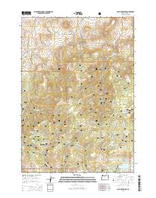
2014 Map of Mule Deer Ridge
USGS Topo · Published 2014About this map
Mule Deer Ridge and the southern slopes of the Maury Mountains dominate this high-elevation landscape in Crook County. Located within the Ochoco National Forest, the terrain is defined by a complex network of seasonal drainages and numerous springs that suggest a reliance on these water sources for both wildlife and high-country livestock grazing. Significant water management features are evident through Newsome Cr Reservoir Number 1, Pine Cr Reservoir, and the Antelope Flat Reservoir, which sit among broad, flat landforms like Flag Flat and Lillie Flat. A system of forest development roads, including the Maury Rd and Nat For Dev Rd 16, provides access to this secluded portion of the forest, while landmarks such as Drake Butte serve as prominent navigational markers above the creek beds of Newsome Cr and Hammer Cr.
Find a feature on this map
40 named features on this map. Tap any name to fly to it.
Don’t see what you’re looking for? This feature index may not catch every label — zoom into the map to look around manually.
Map Details
Editions of this 2014 Mule Deer Ridge Map
This is the sole edition of this map. No revisions or reprints were ever made.
Other maps of this area

1946 · Eagle Rock
USGS Topo · 1:62,500

1948 · Eagle Rock
USGS Topo · 1:62,500

1951 · Post
USGS Topo · 1:62,500

1955 · Crescent
USGS Topo · 1:250,000

1955 · Bend
USGS Topo · 1:250,000

1957 · Crescent
USGS Topo · 1:250,000

1957 · Bend
USGS Topo · 1:250,000

1958 · Crescent
USGS Topo · 1:250,000

1958 · Bend
USGS Topo · 1:250,000
1967 · Sugarloaf Butte
USGS Topo · 1:24,000