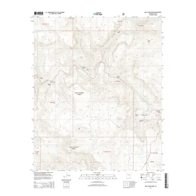
2014 Map of Mule Hoof Bend
USGS Topo · Published 2014About this map
The Salt River Canyon dominates this 2014 survey, cutting through the high desert of the Tonto National Forest. The map centers on the dramatic oxbow at Mule Hoof Bend, where the Salt River winds through deep canyons and the Salt River Valley. To the south, the settlement of Seneca sits along the Us-60 corridor, providing a glimpse into the localized infrastructure of the Gila County interior.
Find a feature on this map
40 named features on this map. Tap any name to fly to it.
Don’t see what you’re looking for? This feature index may not catch every label — zoom into the map to look around manually.
Map Details
Editions of this 2014 Mule Hoof Bend Map
This is the sole edition of this map. No revisions or reprints were ever made.
Other maps of this area

1922 · Chrysotile
USGS Topo · 1:125,000

1946 · Blue House Mtn
USGS Topo · 1:62,500

1951 · Blue House Mtn
USGS Topo · 1:62,500

1954 · Mesa
USGS Topo · 1:250,000

1957 · Mesa
USGS Topo · 1:250,000

1958 · Mesa
USGS Topo · 1:250,000

1960 · Mesa
USGS Topo · 1:250,000

1964 · Mesa
USGS Topo · 1:250,000

1966 · Brushy Canyon
USGS Topo · 1:24,000
1966 · Haystack Butte
USGS Topo · 1:24,000