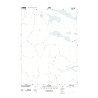
2011 Map of Mule Lake
USGS Topo · Published 2011About this map
Daniels Ranch, Pearson Ranch, and Pound Ranch anchor the isolated landscape of this corner of the Nebraska Sandhills. The terrain is defined by a series of shallow, linear water bodies including Mule Lake, Dads Lake, and the uniquely named Devils Punch Bowl Lake. These lakes are clustered in the northern and eastern portions of the quadrangle, serving as critical landmarks for the sparse ranching operations that characterize the region. The small settlement of Conterra appears in the east, marking a rare point of concentration amidst a vast network of 4WD trails and local roads that navigate the undulating hills. The distribution of these water features, including Rat Lake and Coleman Lake, suggests the specific hydrology required for cattle ranching in this arid environment at the start of the 21st century.
Find a feature on this map
10 named features on this map. Tap any name to fly to it.
Don’t see what you’re looking for? This feature index may not catch every label — zoom into the map to look around manually.
Map Details
Editions of this 2011 Mule Lake Map
This is the sole edition of this map. No revisions or reprints were ever made.
Other maps of this area

1950 · Simeon
USGS Topo · 1:62,500

1950 · Kennedy
USGS Topo · 1:62,500

1951 · Bull Lake
USGS Topo · 1:62,500

1951 · Brownlee
USGS Topo · 1:62,500

1957 · Valentine
USGS Topo · 1:250,000

1959 · Valentine
USGS Topo · 1:250,000

1985 · Goose Creek
USGS Topo · 1:100,000

1985 · Valentine
USGS Topo · 1:100,000
1985 · Kennedy
USGS Topo · 1:24,000
1985 · Brownlee
USGS Topo · 1:24,000