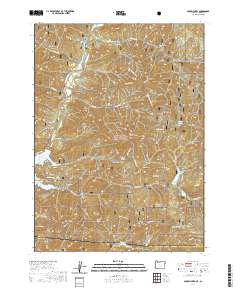
2020 Map of Mule Mountain
USGS Topo · Published 2020About this map
Mule Mountain dominates the high-altitude terrain of the Rogue River National Forest, marking a landscape defined by significant elevation changes and seasonal water systems. The map captures the interaction between the Applegate River and the engineered reservoir of Applegate Lake, a central feature for both drainage and recreation. Historical land-use patterns are evident through the naming of several deep drainage systems like Kilgore Gulch and Sourdough Gulch, while naming conventions such as Iron Hand and Iron Knob suggest the area's mineralogical character. The presence of the Gin Lin trail and Prospectors Loop points to a history of resource extraction and trail development. Higher elevations include Baldy Peak and Little Grayback Mtn, overlooking the secluded Squaw Lakes and Summit Lake near the border with California.
Find a feature on this map
72 named features on this map. Tap any name to fly to it.
Don’t see what you’re looking for? This feature index may not catch every label — zoom into the map to look around manually.
Map Details
Editions of this 2020 Mule Mountain Map
This is the sole edition of this map. No revisions or reprints were ever made.
Other maps of this area

1886 · Shasta
USGS Topo · 1:250,000

1891 · Ashland
USGS Topo · 1:250,000

1893 · Ashland
USGS Topo · 1:250,000

1894 · Shasta
USGS Topo · 1:250,000

1897 · Ashland
USGS Topo · 1:250,000

1908 · Grants Pass
USGS Topo · 1:125,000

1914 · Seiad
USGS Topo · 1:125,000

1922 · Seiad
USGS Topo · 1:125,000

1932 · Yreka
USGS Topo · 1:96,000

1938 · Medford
USGS Topo · 1:125,000