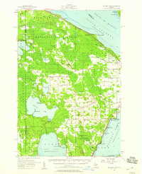
1957 Map of Mullett Lake
USGS Topo · Published 1959About this map
Burt Lake, Mullett Lake, and Douglas Lake dominate this inland landscape, revealing a mid-century Michigan defined by its massive freshwater basins and the Hardwood State Forest. The map documents a rural network of small schoolhouses like School No 1 North and Passino Sch, alongside community anchors such as Sacred Heart Ch and St Johns Ch. The presence of the University of Michigan Biological Station on the shores of South Fishtail Bay highlights the area's long-standing importance for environmental research.
Find a feature on this map
74 named features on this map. Tap any name to fly to it.
Don’t see what you’re looking for? This feature index may not catch every label — zoom into the map to look around manually.
Map Details
Editions of this 1957 Mullett Lake Map
2 editions found
Other maps of this area

1955 · Cheboygan
USGS Topo · 1:250,000

1957 · Tower
USGS Topo · 1:62,500

1957 · Wolverine
USGS Topo · 1:62,500

1957 · Cheboygan
USGS Topo · 1:62,500

1957 · Mullett Lake
USGS Topo · 1:62,500

1958 · Cheboygan
USGS Topo · 1:250,000

1958 · Pellston
USGS Topo · 1:62,500

1958 · Petoskey
USGS Topo · 1:62,500

1964 · Round Island
USGS Topo · 1:24,000
1964 · St. Ignace
USGS Topo · 1:24,000