
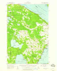
1957 Map of Mullett Lake
USGS Topo · Published 1959About this map
Mullett Lake and Burt Lake dominate this mid-century landscape at the tip of Michigan's Lower Peninsula, connected by a network of creeks and small rivers. The shoreline of Douglas Lake is notably occupied by the University of Michigan Biological Station, while the northern coast meets the Straits of Mackinac at Point Nipigon and Point au Sable. Settlement patterns here reflect the transition from rural townships like Beaugrand and Munro toward seasonal recreation and lakeside development.
Find a feature on this map
73 named features on this map. Tap any name to fly to it.
Don’t see what you’re looking for? This feature index may not catch every label — zoom into the map to look around manually.
Map Details
Editions of this 1957 Mullett Lake Map
2 editions found
Other maps of this area

1955 · Cheboygan
USGS Topo · 1:250,000

1957 · Tower
USGS Topo · 1:62,500

1957 · Wolverine
USGS Topo · 1:62,500

1957 · Cheboygan
USGS Topo · 1:62,500

1958 · Cheboygan
USGS Topo · 1:250,000

1958 · Pellston
USGS Topo · 1:62,500

1958 · Petoskey
USGS Topo · 1:62,500

1964 · Round Island
USGS Topo · 1:24,000
1964 · St. Ignace
USGS Topo · 1:24,000
1964 · McGulpin Point
USGS Topo · 1:24,000