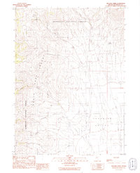
1991 Map of Mullinix Creek
USGS Topo · Published 1991About this map
The Santa Rosa Range dominates the western half of this Nevada landscape, where steep slopes descend into the broad expanse of Paradise Valley to the east. Within the protected boundaries of the Humboldt National Forest, the terrain is defined by a dense network of watercourses, including the central Mullinix Creek and the southern drainage of North Fork Hanson Creek. A notable point of historical interest is the Solid Silver Mine located near Solid Silver Creek in the northwest, reflecting the region's mining heritage. The map details a transition from the high elevations of Tom Basin to the alluvial fans where Big Cottonwood Creek and S Fk Indian Creek reach the valley floor, showing a classic Great Basin environment of isolated peaks and vast basins.
Find a feature on this map
17 named features on this map. Tap any name to fly to it.
Don’t see what you’re looking for? This feature index may not catch every label — zoom into the map to look around manually.
Map Details
Editions of this 1991 Mullinix Creek Map
This is the sole edition of this map. No revisions or reprints were ever made.
Other maps of this area

1882 · Paradise
USGS Topo · 1:250,000

1893 · Paradise
USGS Topo · 1:250,000

1945 · Hot Springs
USGS Topo · 1:62,500

1947 · Hot Springs Peak
USGS Topo · 1:62,500

1955 · McDermitt
USGS Topo · 1:250,000

1958 · Paradise Valley
USGS Topo · 1:62,500

1959 · McDermitt
USGS Topo · 1:250,000

1959 · Hinkey Summit
USGS Topo · 1:62,500

1980 · Black Ridge
USGS Topo · 1:24,000

1980 · Spring City
USGS Topo · 1:24,000