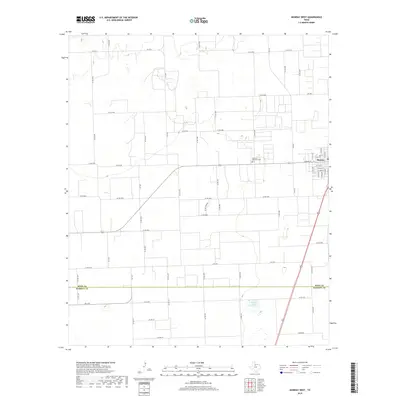
2019 Map of Munday West
USGS Topo · Published 2019About this map
Munday occupies the eastern edge of this agricultural landscape, where the grid of city streets like W Main St and S 12th Ave meets the open farm country of the Texas Rolling Plains. The map documents a strictly organized territory defined by an extensive network of farm-to-market roads and county lines, including Fm 2534 and Co RD 4250. A notable point for local history is the Johnson Memorial Cem, situated west of the main settlement. The terrain is largely defined by large-scale ranching or farming plots, with the boundary between Knox Co and Haskell Co running across the southern portion of the quadrangle. Water is scarce in this environment, with Griffin Lake serving as a significant hydrological feature in the southern section.
Find a feature on this map
70 named features on this map. Tap any name to fly to it.
Don’t see what you’re looking for? This feature index may not catch every label — zoom into the map to look around manually.
Map Details
Editions of this 2019 Munday West Map
This is the sole edition of this map. No revisions or reprints were ever made.
Other maps of this area

1954 · Wichita Falls
USGS Topo · 1:250,000

1958 · Wichita Falls
USGS Topo · 1:250,000

1967 · Hefner
USGS Topo · 1:24,000

1967 · Benjamin
USGS Topo · 1:24,000

1967 · Rochester
USGS Topo · 1:24,000

1967 · Weinert
USGS Topo · 1:24,000

1967 · Rhineland
USGS Topo · 1:24,000

1967 · Mattson
USGS Topo · 1:24,000

1968 · Munday West
USGS Topo · 1:24,000
1968 · Munday East
USGS Topo · 1:24,000