1968 Map of Munden
USGS Topo · Published 1971About this map
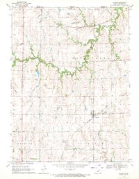
Munden serves as the primary rail and community hub on this north-central Kansas landscape, situated where the Chicago Rock Island and Pacific line cuts through the rolling agricultural plains. The map illustrates a region defined by its township structure, including Rose Creek, Freedom, and Fairview, and is marked by the dendritic drainage patterns of Rose Creek, Salt Creek, and the North Fork Mill Creek. Along the northern border, the Nebraska Kansas state line separates Republic County from Thayer County, with the Burlington Northern railroad traversing the area near Hubbell Cem. Local community life is anchored by landmarks like the Excelsior Community Center and the Rose Creek Cem, while a Sandpit in the southern reaches points to local resource extraction amidst the farm fields.
Find a feature on this map
17 named features on this map. Tap any name to fly to it.
Don’t see what you’re looking for? This feature index may not catch every label — zoom into the map to look around manually.
Map Details
Editions of this 1968 Munden Map
This is the sole edition of this map. No revisions or reprints were ever made.
Other maps of this area

1892 · Concordia
USGS Topo · 1:125,000

1893 · Washington
USGS Topo · 1:125,000

1898 · Hebron
USGS Topo · 1:125,000

1955 · Manhattan
USGS Topo · 1:250,000

1955 · Lincoln
USGS Topo · 1:250,000

1956 · Manhattan
USGS Topo · 1:250,000

1957 · Manhattan
USGS Topo · 1:250,000

1957 · Lincoln
USGS Topo · 1:250,000

1958 · Lincoln
USGS Topo · 1:250,000
1960 · Chester
USGS Topo · 1:24,000