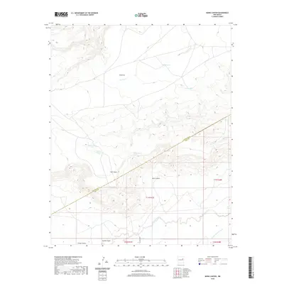
2020 Map of Muniz Canyon
USGS Topo · Published 2020About this map
Mesa Rica dominates the northern reaches of this landscape, its broad plateau carved by the seasonal drainage of Alamosa Cr and Oso Cr. The terrain shifts dramatically southward where the high ground gives way to a complex system of breaks and drainages. The San Miguel and Quay County line strikes diagonally across the central portion of the map, cutting through Muniz Canyon and near the head of Vigil Canyon. This area is characterized by a high-desert ranching economy, evidenced by numerous water catchments like Muniz Tank, Horton Tank, and Feed Pasture Tank. In the south, the land flattens toward the wide valley of Pajarito Creek, which is joined by Arroyo de las Palomas near the southern boundary. These ephemeral water sources were critical for the development of the region's expansive grazing lands.
Find a feature on this map
21 named features on this map. Tap any name to fly to it.
Don’t see what you’re looking for? This feature index may not catch every label — zoom into the map to look around manually.
Map Details
Editions of this 2020 Muniz Canyon Map
This is the sole edition of this map. No revisions or reprints were ever made.
Other maps of this area

1930 · Tucumcari
USGS Topo · 1:125,000

1954 · Santa Fe
USGS Topo · 1:250,000

1954 · Tucumcari
USGS Topo · 1:250,000

1958 · Santa Fe
USGS Topo · 1:250,000

1958 · Tucumcari
USGS Topo · 1:250,000

1964 · Muniz Canyon
USGS Topo · 1:24,000

1964 · Gate Canyon
USGS Topo · 1:24,000
1964 · Montoya
USGS Topo · 1:24,000

1964 · Ortega Tank
USGS Topo · 1:24,000

1967 · Tenaja Mesa
USGS Topo · 1:24,000