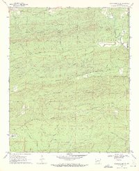
1970 Map of Murfreesboro NE
USGS Topo · Published 1972About this map
Kirby Mountain and Wall Mountain dominate the skyline of this part of northern Pike County, where the drainage network of the Antoine River carves through the terrain. The landscape is marked by a series of narrow gaps and ridges, such as Lassie Gap and Motley Gap, which influenced the placement of early routes like the Old Hot Spring Road. Settled pockets are evidenced by numerous small family and community burial grounds, including Macedonia Cem, Wall Creek Cem, and Woodall Cem. Resource extraction is noted by a Shale Pit and a scattered Mine, while the infrastructure of the late 1960s is represented by the Pipeline Road and a series of rugged trails like Rattler Trail and Worthy Switch Trail.
Find a feature on this map
36 named features on this map. Tap any name to fly to it.
Don’t see what you’re looking for? This feature index may not catch every label — zoom into the map to look around manually.
Map Details
Editions of this 1970 Murfreesboro NE Map
2 editions found
Other maps of this area

1906 · Caddo Gap
USGS Topo · 1:125,000

1936 · Glenwood
USGS Topo · 1:48,000

1942 · Glenwood
USGS Topo · 1:62,500

1943 · Antoine
USGS Topo · 1:62,500

1949 · Glenwood
USGS Topo · 1:62,500

1955 · Little Rock
USGS Topo · 1:250,000

1956 · Little Rock
USGS Topo · 1:250,000

1960 · Little Rock
USGS Topo · 1:250,000

1964 · Little Rock
USGS Topo · 1:250,000
1966 · Amity
USGS Topo · 1:24,000