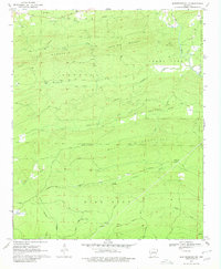
1970 Map of Murfreesboro NE
USGS Topo · Published 1980About this map
Kirby Mountain and Wall Mountain dominate this part of Pike County, where a network of ridgeline gaps and creek valleys dictated the local geography long before modern development. In the late 1960s, the landscape remained deeply rural, defined by a series of family-named cemeteries such as Valley Grove Cem, Woodall Cem, and Woods Cem that provide vital touchpoints for genealogists. Waterways like Little Antoine Creek and Caney Fork carve through the terrain, while the presence of a Shale Pit and various unnamed mines suggests the small-scale extractive industries of the period. The map traces several specialized tracks, including the Worthy Switch Trail and Deer Run Loop, reflecting a transition from early timber or rail corridors to recreational use. This survey captures the county line at Pike Co Clark Co, documenting the winding forest roads and isolated homesteads of the Ouachita foothills.
Find a feature on this map
31 named features on this map. Tap any name to fly to it.
Don’t see what you’re looking for? This feature index may not catch every label — zoom into the map to look around manually.
Map Details
Editions of this 1970 Murfreesboro NE Map
2 editions found
Other maps of this area

1906 · Caddo Gap
USGS Topo · 1:125,000

1936 · Glenwood
USGS Topo · 1:48,000

1942 · Glenwood
USGS Topo · 1:62,500

1943 · Antoine
USGS Topo · 1:62,500

1949 · Glenwood
USGS Topo · 1:62,500

1955 · Little Rock
USGS Topo · 1:250,000

1956 · Little Rock
USGS Topo · 1:250,000

1960 · Little Rock
USGS Topo · 1:250,000

1964 · Little Rock
USGS Topo · 1:250,000
1966 · Amity
USGS Topo · 1:24,000