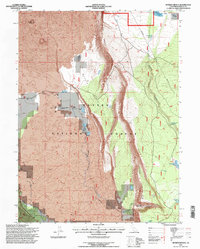
1995 Map of Murken Bench
USGS Topo · Published 1997About this map
Lassen National Forest terrain is dramatically defined by the volcanic geological features of the Hat Creek Rim and the wide expanse of Murken Bench. The landscape is a complex mix of basaltic flows and water management, where numerous small water bodies like Alcohol Jacks Reservoir, Bald Mountain Reservoir, and Murken Lake support the high-elevation environment. The survey reveals specialized scientific and utility infrastructure, notably the University of California Observatory and various radio facilities located near Cinder Butte. Human presence in this section of Shasta County is marked by the Bidwell Ranch and the settlement at Wilcox, alongside established features such as a small Cem and Government Well. The map highlights the sharp contrast between the jagged Lava fields and the riparian corridors of Hat Creek and Lost Creek.
Find a feature on this map
26 named features on this map. Tap any name to fly to it.
Don’t see what you’re looking for? This feature index may not catch every label — zoom into the map to look around manually.
Map Details
Editions of this 1995 Murken Bench Map
This is the sole edition of this map. No revisions or reprints were ever made.
Other maps of this area

1886 · Lassen Peak
USGS Topo · 1:250,000

1892 · Lassen Peak
USGS Topo · 1:250,000

1894 · Lassen Peak
USGS Topo · 1:250,000

1935 · Burney
USGS Topo · 1:96,000

1939 · Burney
USGS Topo · 1:125,000

1939 · Halls Flat
USGS Topo · 1:125,000

1955 · Westwood
USGS Topo · 1:250,000

1956 · Manzanita Lake
USGS Topo · 1:62,500

1957 · Prospect Peak
USGS Topo · 1:62,500

1957 · Burney
USGS Topo · 1:62,500