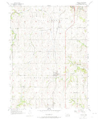
1956 Map of Murray
USGS Topo · Published 1974About this map
The Missouri Pacific railroad corridor anchors the rural landscape of eastern Cass County in the mid-1950s, connecting the village of Murray with the northern settlement of Mynard and the southern stop at Todd. This area is characterized by a dense network of one-room schoolhouses and family-named landmarks, reflecting a well-established agricultural society before the consolidation of rural districts. Notable educational sites such as Ameck Sch, Jean Sch, and Cottonwood Sch are scattered across the terrain, serving the farming families of West Rock Bluffs and East Rock Bluffs.
Find a feature on this map
28 named features on this map. Tap any name to fly to it.
Don’t see what you’re looking for? This feature index may not catch every label — zoom into the map to look around manually.
Map Details
Editions of this 1956 Murray Map
3 editions found

Other maps of this area

1893 · Fremont
USGS Topo · 1:125,000

1896 · Fremont
USGS Topo · 1:125,000

1903 · Weeping Water
USGS Topo · 1:125,000

1929 · Weeping Water
USGS Topo · 1:125,000

1935 · Nehawka
USGS Topo · 1:48,000

1940 · Nehawka
USGS Topo · 1:62,500

1954 · Omaha
USGS Topo · 1:250,000

1955 · Fremont
USGS Topo · 1:250,000

1955 · Nebraska City
USGS Topo · 1:250,000

1955 · Lincoln
USGS Topo · 1:250,000