
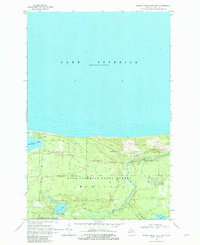
1968 Map of Muskallonge Lake East
USGS Topo · Published 1970About this map
Deer Park and the rugged northern shoreline of the Upper Peninsula define this late-1960s landscape, where the waters of Lake Superior meet the sand-dune and forest geography of the Lake Superior State Forest. The map captures a transition in land use, showing the remnants of industrial history alongside developing recreational sites. A notable Old Railroad Grade cuts through the timberland, serving as a silent marker of the region's logging era, while the Hearted River winds its way toward the coast through a network of small interior lakes including Connor Lakes and Perch Lake.
Find a feature on this map
20 named features on this map. Tap any name to fly to it.
Don’t see what you’re looking for? This feature index may not catch every label — zoom into the map to look around manually.
Map Details
Editions of this 1968 Muskallonge Lake East Map
2 editions found
Other maps of this area

1954 · Sault Sainte Marie
USGS Topo · 1:250,000

1956 · Sault Sainte Marie
USGS Topo · 1:250,000

1957 · Sault Sainte Marie
USGS Topo · 1:250,000

1958 · Sault Sainte Marie
USGS Topo · 1:250,000

1968 · Muskallonge Lake SW
USGS Topo · 1:24,000

1968 · Muskallonge Lake West
USGS Topo · 1:24,000

1968 · Muskallonge Lake SE
USGS Topo · 1:24,000

1968 · Betsy Lake NW
USGS Topo · 1:24,000

1968 · Betsy Lake SW
USGS Topo · 1:24,000
1985 · Two Hearted River
USGS Topo · 1:100,000