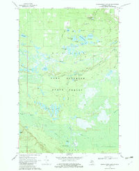
1968 Map of Muskallonge Lake SW
USGS Topo · Published 1982About this map
The Lake Superior State Forest dominates this landscape in Luce County, Michigan, defined by the intricate hydrological network of the Upper Peninsula. At the heart of this 1968 survey are the multiple tributaries of the famed Two Hearted River system, including the North Branch, West Branch, and South Branch. These waterways wind through dense wetlands and timberland, feeding into numerous backcountry basins like Evergreen Lake, Ladue Lake, and the Two Hearted Lakes. Primitive transportation routes such as the Camp Ohio Road and various Jeep Trails provide the only access to these secluded interior woods. Recreational activity is concentrated near Holland Lake, where the West Lookout Tower Campground offers a base for exploring the surrounding Beaverhouse Lakes and North Branch Lakes. The map reveals a wild, swampy terrain where small streams like Dairy Creek and South Creek drain into the primary river branches.
Find a feature on this map
42 named features on this map. Tap any name to fly to it.
Don’t see what you’re looking for? This feature index may not catch every label — zoom into the map to look around manually.
Map Details
Editions of this 1968 Muskallonge Lake SW Map
2 editions found
Other maps of this area

1954 · Sault Sainte Marie
USGS Topo · 1:250,000

1956 · Sault Sainte Marie
USGS Topo · 1:250,000

1957 · Sault Sainte Marie
USGS Topo · 1:250,000

1958 · Sault Sainte Marie
USGS Topo · 1:250,000

1962 · Auger Lake
USGS Topo · 1:24,000

1968 · Muskallonge Lake East
USGS Topo · 1:24,000

1968 · Muskallonge Lake SW
USGS Topo · 1:24,000

1968 · Muskallonge Lake West
USGS Topo · 1:24,000

1968 · Muskallonge Lake SE
USGS Topo · 1:24,000
1968 · Grand Marais SE
USGS Topo · 1:24,000