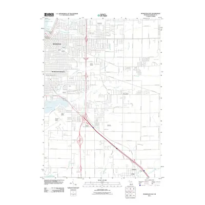
2011 Map of Muskegon East
USGS Topo · Published 2011About this map
Muskegon and its industrial neighbor Muskegon Heights dominate the western portion of this 2011 survey, showing an urban landscape defined by an extensive network of cemeteries and civic infrastructure. The city's eastern expansion is marked by numerous memorial sites including Oakwood Cemetery, Sunrise Memorial Gardens, and the Saint Paul's Episcopal Church Columbarium. Significant transportation and recreation hubs are prominent, most notably the Muskegon County Airport and the Great Lakes Downs Thoroughbred Race Course.
Find a feature on this map
76 named features on this map. Tap any name to fly to it.
Don’t see what you’re looking for? This feature index may not catch every label — zoom into the map to look around manually.
Map Details
Editions of this 2011 Muskegon East Map
This is the sole edition of this map. No revisions or reprints were ever made.
Other maps of this area

1929 · Montague
USGS Topo · 1:48,000

1930 · Lake Harbor
USGS Topo · 1:48,000

1930 · Muskegon
USGS Topo · 1:62,500

1936 · Muskegon
USGS Topo · 1:62,500

1936 · Lake Harbor
USGS Topo · 1:62,500

1954 · Milwaukee
USGS Topo · 1:250,000

1958 · Milwaukee
USGS Topo · 1:250,000

1958 · Twin Lake
USGS Topo · 1:62,500

1959 · Montague
USGS Topo · 1:62,500
1972 · Sullivan
USGS Topo · 1:24,000