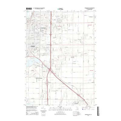
2014 Map of Muskegon East
USGS Topo · Published 2014About this map
Mona Lake and the southeastern residential sprawl of Muskegon dominate this 2014 survey, illustrating the complex hydrology of coastal Michigan. The landscape is defined by its numerous burial grounds, including the historic Oakwood Cem and Evergreen Cem, which serve as significant sites for local genealogical research. In the south, Norton Shores surrounds the Muskegon County Airport, while the smaller community of Fruitport sits near the shores of Little Black Lake. This era shows a fully developed transportation network, where major roads like Apple Ave and E Sherman Blvd connect the urban core to outlying settlements like Wolf Lake and Cloverville. The mapping of small tributaries such as Black Cr and Ryerson Cr highlights the drainage patterns flowing toward the lakefront industrial and residential zones.
Find a feature on this map
86 named features on this map. Tap any name to fly to it.
Don’t see what you’re looking for? This feature index may not catch every label — zoom into the map to look around manually.
Map Details
Editions of this 2014 Muskegon East Map
This is the sole edition of this map. No revisions or reprints were ever made.
Other maps of this area

1929 · Montague
USGS Topo · 1:48,000

1930 · Lake Harbor
USGS Topo · 1:48,000

1930 · Muskegon
USGS Topo · 1:62,500

1936 · Muskegon
USGS Topo · 1:62,500

1936 · Lake Harbor
USGS Topo · 1:62,500

1954 · Milwaukee
USGS Topo · 1:250,000

1958 · Milwaukee
USGS Topo · 1:250,000

1958 · Twin Lake
USGS Topo · 1:62,500

1959 · Montague
USGS Topo · 1:62,500
1972 · Sullivan
USGS Topo · 1:24,000