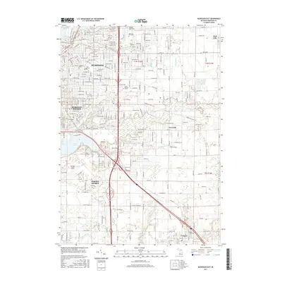
2017 Map of Muskegon East
USGS Topo · Published 2017About this map
Muskegon and its southern neighbors develop along a complex network of waterways and recreational corridors in this 2017 survey. The industrial and residential character of Muskegon Heights and Norton Shores is defined by their proximity to Mona Lake and the vast Muskegon County Airport. For local historians and genealogists, the map provides precise locations for numerous burial grounds, including Evergreen Cem, Oakwood Cem, and the Sunrise Memorial Gardens near the highway corridors.
Find a feature on this map
33 named features on this map. Tap any name to fly to it.
Don’t see what you’re looking for? This feature index may not catch every label — zoom into the map to look around manually.
Map Details
Editions of this 2017 Muskegon East Map
This is the sole edition of this map. No revisions or reprints were ever made.
Other maps of this area

1929 · Montague
USGS Topo · 1:48,000

1930 · Lake Harbor
USGS Topo · 1:48,000

1930 · Muskegon
USGS Topo · 1:62,500

1936 · Muskegon
USGS Topo · 1:62,500

1936 · Lake Harbor
USGS Topo · 1:62,500

1954 · Milwaukee
USGS Topo · 1:250,000

1958 · Milwaukee
USGS Topo · 1:250,000

1958 · Twin Lake
USGS Topo · 1:62,500

1959 · Montague
USGS Topo · 1:62,500
1972 · Sullivan
USGS Topo · 1:24,000