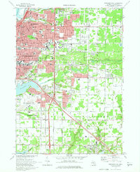
1972 Map of Muskegon East
USGS Topo · Published 1975About this map
Muskegon and its southern suburbs are depicted here during a period of significant mid-century expansion, centered on the corridor between Muskegon Lake and Mona Lake. The industrial and residential growth of Muskegon Heights is evident, while the development of Norton Shores to the south shows the shift toward suburban neighborhoods surrounding the Muskegon County Airport. This landscape is marked by a high density of community infrastructure, from local parish schools like St Michaels Sch and St Jean Baptiste Sch to larger medical facilities such as Mercy Hosp.
Find a feature on this map
145 named features on this map. Tap any name to fly to it.
Don’t see what you’re looking for? This feature index may not catch every label — zoom into the map to look around manually.
Map Details
Editions of this 1972 Muskegon East Map
2 editions found
Other maps of this area

1929 · Montague
USGS Topo · 1:48,000

1930 · Lake Harbor
USGS Topo · 1:48,000

1930 · Muskegon
USGS Topo · 1:62,500

1936 · Muskegon
USGS Topo · 1:62,500

1936 · Lake Harbor
USGS Topo · 1:62,500

1954 · Milwaukee
USGS Topo · 1:250,000

1958 · Milwaukee
USGS Topo · 1:250,000

1958 · Twin Lake
USGS Topo · 1:62,500

1959 · Montague
USGS Topo · 1:62,500
1972 · Sullivan
USGS Topo · 1:24,000