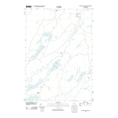
2010 Map of Muskellunge Lake
USGS Topo · Published 2010About this map
Oxbow sits along a sharp bend of the Oswegatchie River at the eastern edge of this landscape, serving as a focal point for the surrounding rural road network. To the north, the Indian River winds toward several prominent burial grounds, including Saint Patricks Cemetery and Riverside Cemetery. The terrain is defined by a dense cluster of interconnected water bodies, from the irregular shores of Muskellunge Lake and its distinctive features like Elephants Foot and Muskellunge Point, to the elongated reaches of Lake of the Woods and Grass Lake. Historic rural intersections such as Nelson Corner, Bartletts Corner, and Chapel Corners anchor the upland regions. Natural landmarks like Pulpit Rock near Payne Lake suggest a landscape shaped by glacial activity, while scattered settlements like Honey Hill reflect the long-standing agricultural and recreational character of this northern New York region.
Find a feature on this map
32 named features on this map. Tap any name to fly to it.
Don’t see what you’re looking for? This feature index may not catch every label — zoom into the map to look around manually.
Map Details
Editions of this 2010 Muskellunge Lake Map
This is the sole edition of this map. No revisions or reprints were ever made.
Other maps of this area

1903 · Alexandria Bay
USGS Topo · 1:62,500

1903 · Theresa
USGS Topo · 1:62,500

1911 · Antwerp
USGS Topo · 1:62,500

1912 · Hammond
USGS Topo · 1:62,500

1943 · Redwood
USGS Topo · 1:31,680

1944 · Hammond
USGS Topo · 1:62,500

1948 · Theresa
USGS Topo · 1:24,000

1948 · Chippewa Bay
USGS Topo · 1:24,000
1948 · Theresa
USGS Topo · 1:62,500

1948 · Alexandria Bay
USGS Topo · 1:62,500