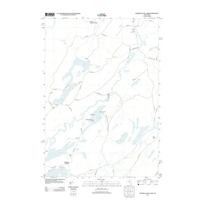
2013 Map of Muskellunge Lake
USGS Topo · Published 2013About this map
Muskellunge Lake and the winding Indian River dominate this pocket of Jefferson County, where the landscape is defined by an intricate network of waterways and glacial terrain features. The area around Nelson Corner and Chapel Corners reflects a long-standing rural settlement pattern, with local history preserved at Riverside Cem and Saint Patricks Cem near the northern border. Smaller water bodies like Grass Lake, Payne Lake, and Red Lake are connected by creeks such as Dodds Cr and Vrooman Cr, illustrating a complex hydrography that has shaped local land use for generations. Distinctive landmarks like Pulpit Rock, Elephants Foot, and Honey Hill rise above the basin, providing clear orientation points for researchers tracing old property lines or recreational history. The map also shows the crossing at Hanson Bridge, a key transit point across the river system that links these dispersed lakeside communities.
Find a feature on this map
66 named features on this map. Tap any name to fly to it.
Don’t see what you’re looking for? This feature index may not catch every label — zoom into the map to look around manually.
Map Details
Editions of this 2013 Muskellunge Lake Map
This is the sole edition of this map. No revisions or reprints were ever made.
Other maps of this area

1903 · Alexandria Bay
USGS Topo · 1:62,500

1903 · Theresa
USGS Topo · 1:62,500

1911 · Antwerp
USGS Topo · 1:62,500

1912 · Hammond
USGS Topo · 1:62,500

1943 · Redwood
USGS Topo · 1:31,680

1944 · Hammond
USGS Topo · 1:62,500

1948 · Theresa
USGS Topo · 1:24,000

1948 · Chippewa Bay
USGS Topo · 1:24,000
1948 · Theresa
USGS Topo · 1:62,500

1948 · Alexandria Bay
USGS Topo · 1:62,500