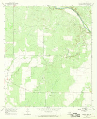
1967 Map of Mustang Creek
USGS Topo · Published 1969About this map
Colorado River frontage defines the northeastern corner of this Concho County landscape, where the river serves as the natural boundary between Concho and Coleman counties. The terrain is deeply carved by a complex drainage system, most notably the confluence of the North Fork, West Fork, and Middle Fork of Mustang Creek. These waterways converge near the western edge of the quadrangle, shaping the local topography and land use patterns of the late 1960s. Rural life is anchored by landmarks such as the Stevens Ranch and the Millersview Cem, while industrial activity is evidenced by scattered Gravel Pits and a Gas Well. The survey detail even includes fine-grained features like an Athletic Field and a network of selected fence lines, providing a clear view of the ranching and resource extraction economy of this Texas region.
Find a feature on this map
18 named features on this map. Tap any name to fly to it.
Don’t see what you’re looking for? This feature index may not catch every label — zoom into the map to look around manually.
Map Details
Editions of this 1967 Mustang Creek Map
3 editions found
Other maps of this area

1892 · Eden
USGS Topo · 1:125,000

1892 · Ballinger
USGS Topo · 1:125,000

1896 · Eden
USGS Topo · 1:125,000

1924 · Eden 1-a
USGS Topo · 1:48,000

1925 · Ballinger 3-d
USGS Topo · 1:48,000

1925 · Ballinger 4-c
USGS Topo · 1:48,000

1931 · Stacy
USGS Topo · 1:62,500

1932 · Voss
USGS Topo · 1:62,500

1932 · Paint Rock
USGS Topo · 1:62,500

1954 · Brownwood
USGS Topo · 1:250,000