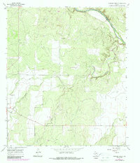
1967 Map of Mustang Creek
USGS Topo · Published 1987About this map
Colorado River frontage defines the northern edge of this Concho County landscape, where the terrain breaks into the branching drainage system of Mustang Creek. This 1967 survey (updated with 1980s photorevisions) captures the rural transition between the high plateaus and the river valley, characterized by ranching infrastructure and intermittent stream beds. The map documents scattered agricultural and industrial marks, including the Stevens Ranch and several Gravel Pits that suggest the local extraction economy of the mid-20th century.
Find a feature on this map
17 named features on this map. Tap any name to fly to it.
Don’t see what you’re looking for? This feature index may not catch every label — zoom into the map to look around manually.
Map Details
Editions of this 1967 Mustang Creek Map
3 editions found
Other maps of this area

1892 · Eden
USGS Topo · 1:125,000

1892 · Ballinger
USGS Topo · 1:125,000

1896 · Eden
USGS Topo · 1:125,000

1924 · Eden 1-a
USGS Topo · 1:48,000

1925 · Ballinger 3-d
USGS Topo · 1:48,000

1925 · Ballinger 4-c
USGS Topo · 1:48,000

1931 · Stacy
USGS Topo · 1:62,500

1932 · Voss
USGS Topo · 1:62,500

1932 · Paint Rock
USGS Topo · 1:62,500

1954 · Brownwood
USGS Topo · 1:250,000