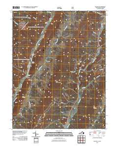
2011 Map of Mustoe
USGS Topo · Published 2011About this map
Mustoe and Vanderpool anchor this mountain landscape, where the Jackson River and Back Creek carve deep pathways through the ridges. The terrain is defined by a series of prominent gaps and drafts, such as Vanderpool Gap, Mill Gap, and Ruckman Draft, which historically dictated the flow of travel and settlement in this portion of the Highlands. Significant elevation changes are marked by Back Creek Mountain and Little Mountain, creating a confined geography where human activity is concentrated in the narrow valleys.
Find a feature on this map
35 named features on this map. Tap any name to fly to it.
Don’t see what you’re looking for? This feature index may not catch every label — zoom into the map to look around manually.
Map Details
Editions of this 2011 Mustoe Map
This is the sole edition of this map. No revisions or reprints were ever made.
Other maps of this area

1901 · Monterey
USGS Topo · 1:125,000

1922 · Cass
USGS Topo · 1:48,000

1923 · Warm Springs
USGS Topo · 1:48,000

1924 · Cass
USGS Topo · 1:62,500

1926 · Warm Springs
USGS Topo · 1:62,500

1941 · Monterey
USGS Topo · 1:62,500

1944 · Monterey
USGS Topo · 1:62,500

1946 · Warm Springs
USGS Topo · 1:62,500

1946 · Williamsville
USGS Topo · 1:62,500

1949 · Charlottesville
USGS Topo · 1:250,000