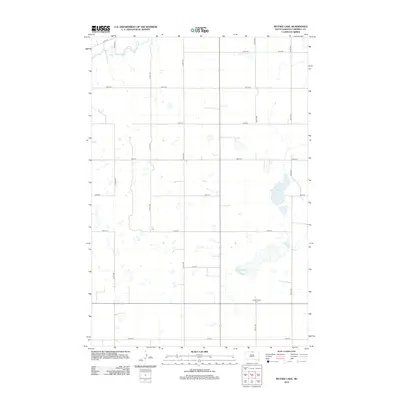
2012 Map of Mutske Lake
USGS Topo · Published 2012About this map
Hoffnungstal Cem serves as a significant genealogical marker in this section of Campbell County, situated among the prairie potholes and agricultural sections of northern South Dakota. The landscape is defined by its glacial hydrology, most notably Mutske Lake, which sits in the eastern half of the map. The area's organization follows a strict section-line grid, represented by an extensive network of local roads including 105th St at the northern boundary and 113th St to the south. These corridors, such as 316th Ave and 321st Ave, illustrate the enduring homestead-era land division that continues to shape the rural geography of the region. Dozens of unnamed wetlands and small water bodies punctuate the terrain, indicating the seasonal drainage patterns typical of this portion of the Missouri Plateau.
Find a feature on this map
15 named features on this map. Tap any name to fly to it.
Don’t see what you’re looking for? This feature index may not catch every label — zoom into the map to look around manually.
Map Details
Editions of this 2012 Mutske Lake Map
This is the sole edition of this map. No revisions or reprints were ever made.
Other maps of this area

1954 · Aberdeen
USGS Topo · 1:250,000

1956 · Aberdeen
USGS Topo · 1:250,000

1978 · Greenway
USGS Topo · 1:24,000

1978 · Salt Lake
USGS Topo · 1:24,000

1978 · Zeeland
USGS Topo · 1:24,000
1978 · Zeeland NW
USGS Topo · 1:24,000

1978 · Eureka West
USGS Topo · 1:24,000

1978 · Flat Lake
USGS Topo · 1:24,000

1978 · Feinstein Lake
USGS Topo · 1:24,000

1978 · Mutske Lake
USGS Topo · 1:24,000