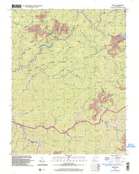
1996 Map of Myrtle
USGS Topo · Published 2003About this map
Laurel Creek State Wildlife Management Area dominates this portion of Mingo County, showcasing a landscape defined by the winding drainages of Pigeon Creek and Twelvepole Creek. The mid-1990s terrain is marked by significant industrial activity, including a prominent Conveyor system near a Strip Mine and Mine Dump in the northeast. Small hollow-based settlements like Myrtle, Scarlet, and Dingess are connected by narrow roads following the creek beds, a typical settlement pattern for this coal-bearing region. Genealogists will find an exceptional density of family-named burial sites, such as Ooten Cem, Gilman Cem, and Marcum Cem, alongside rural landmarks like the Lily of the Valley Ch and Bethany Ch. This survey captures the area just as the boundary between the Kermit and Harvey districts was established, reflecting a moment of transition for these mountain communities.
Find a feature on this map
64 named features on this map. Tap any name to fly to it.
Don’t see what you’re looking for? This feature index may not catch every label — zoom into the map to look around manually.
Map Details
Editions of this 1996 Myrtle Map
This is the sole edition of this map. No revisions or reprints were ever made.
Other maps of this area

1887 · Warfield
USGS Topo · 1:125,000

1891 · Warfield
USGS Topo · 1:125,000

1909 · Matewan
USGS Topo · 1:48,000

1910 · Holden
USGS Topo · 1:48,000

1910 · Naugatuck
USGS Topo · 1:48,000

1912 · Naugatuck
USGS Topo · 1:62,500

1912 · Holden
USGS Topo · 1:62,500

1915 · Williamson
USGS Topo · 1:48,000

1915 · Naugatuck
USGS Topo · 1:48,000

1915 · Matewan
USGS Topo · 1:48,000