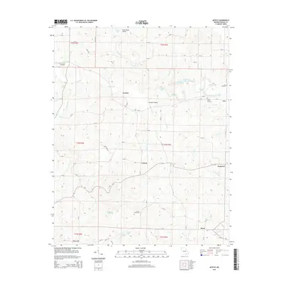
2015 Map of Myrtle
USGS Topo · Published 2015About this map
Myrtle and the surrounding borderlands of Oregon County are defined by a network of spring-fed creeks and rural hamlets in this detailed 2015 study. The landscape is characterized by its distinct hydrography, featuring named points such as Pine Log Hole, Shipman Hole, and Rocky Hole along Piney Cr. These specific deep-water markers, along with Hesley Spring and Gum Spring, illustrate the importance of reliable water sources to the dispersed settlements of Guiteau and Garfield.
Find a feature on this map
75 named features on this map. Tap any name to fly to it.
Don’t see what you’re looking for? This feature index may not catch every label — zoom into the map to look around manually.
Map Details
Editions of this 2015 Myrtle Map
This is the sole edition of this map. No revisions or reprints were ever made.
Other maps of this area

1941 · Gatewood
USGS Topo · 1:62,500

1944 · Couch
USGS Topo · 1:62,500

1945 · Gatewood
USGS Topo · 1:62,500

1946 · Couch
USGS Topo · 1:62,500

1957 · Poplar Bluff
USGS Topo · 1:250,000

1959 · Poplar Bluff
USGS Topo · 1:250,000

1960 · Poplar Bluff
USGS Topo · 1:250,000
1965 · Riverton
USGS Topo · 1:24,000
1966 · Billmore
USGS Topo · 1:24,000
1968 · Hardy NE
USGS Topo · 1:24,000