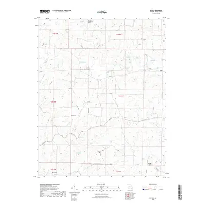
2017 Map of Myrtle
USGS Topo · Published 2017About this map
Myrtle serves as the primary hub in this corner of Oregon County, where the landscape is defined by the winding course of Mill Cr and its numerous tributaries. The area's rural character is marked by small settlements like Garfield, Jobe, and Farewell, which anchor a network of local roads such as Louise Creek Rd and E Walnut St. This 2017 survey reveals a distinctive hydrographic pattern, featuring numerous named "holes" and small lakes, including Pine Log Hole, Shipman Hole, Hughes Lake, and Frey Lake, suggesting a terrain where water frequently pools in natural depressions or creek bends.
Find a feature on this map
83 named features on this map. Tap any name to fly to it.
Don’t see what you’re looking for? This feature index may not catch every label — zoom into the map to look around manually.
Map Details
Editions of this 2017 Myrtle Map
This is the sole edition of this map. No revisions or reprints were ever made.
Other maps of this area

1941 · Gatewood
USGS Topo · 1:62,500

1944 · Couch
USGS Topo · 1:62,500

1945 · Gatewood
USGS Topo · 1:62,500

1946 · Couch
USGS Topo · 1:62,500

1957 · Poplar Bluff
USGS Topo · 1:250,000

1959 · Poplar Bluff
USGS Topo · 1:250,000

1960 · Poplar Bluff
USGS Topo · 1:250,000
1965 · Riverton
USGS Topo · 1:24,000
1966 · Billmore
USGS Topo · 1:24,000
1968 · Hardy NE
USGS Topo · 1:24,000